- Thumbnail
- Resource ID
- f4927802-8c8e-11eb-9f82-0242ac120005
- Title
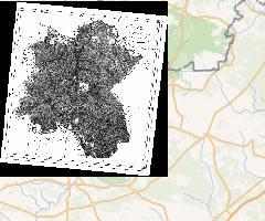
- Mapa Puszczy Białowieskiej z 1830 roku, georeferencjonowana
- Date
- March 24, 2021, 10:53 a.m., Publication
- Abstract
- Mapa Puszczy Białowieskiej, autor nieznany (z: E. K. Eichwald, Naturhistorische Skizze von Lithauen, Volhynien und Podolien, Wilno 1830)
- Edition
- --
- Responsible
- MRIPAS
- Point of Contact
- openforestdata@pb.edu.pl
- Purpose
- --
- Maintenance Frequency
- None
- Type
- grid
- Restrictions
- None
- License
- Not Specified
- Language
- pol
- Temporal Extent
- Start
- Jan. 1, 1830, 11:53 a.m.
- End
- Dec. 31, 1830, 11:54 a.m.
- Supplemental Information
- Nie podano informacji
- Data Quality
- --
- Extent
-
- x0: 23.442727965000000
- x1: 24.280727965000000
- y0: 52.427196167000000
- y1: 52.955196167000000
- Spatial Reference System Identifier
- EPSG:4326
- Keywords
- no keywords
- Category
- Imagery Base Maps Earth Cover
- Regions
-
Global
,
Europe
,
Poland